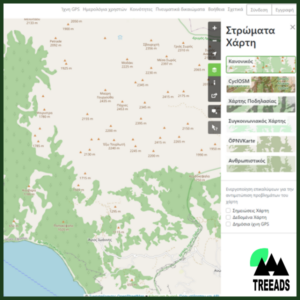
A web-based GIS platform harnessing Copernicus services and a four-layer approach for hotspot detection, fire potential analysis, and early warning of natural disasters. Focused on Land Surface Temperature, it excels in recognizing vital fire elements like smoke columns and socio-agricultural activities. Utilizing EO Browser imagery, the toolkit provides varied warnings for comprehensive landscape management, unveiling a service for early detection of potential natural disasters.
Early Warning System and Landscape Management Toolkit
Related products
-
Austrian
Map service based on OpenStreetMap